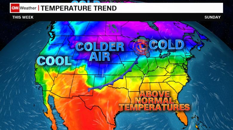
Winter is creeping in early as two separate systems bring snow and ice from Washington to Wisconsin. Even southern states like Oklahoma and Texas are in for a big chill through this weekend.
Nearly five million Americans will be under a winter storm warning, winter storm watch or winter weather advisory over the next 48 hours, and that number is likely to increase as the second system spreads east.
A band of heavy snow is spreading across the Upper Midwest Thursday into Friday. Snowfall totals up to 8 inches are possible in some locations. Then another round of heavy snow will drop into the Northern Rockies and move across the Upper Midwest through the weekend.
Record early snowfall
Just two days after Minneapolis saw a record 7.9 inches of snow on Tuesday, more snow is set to arrive in the next few days. The record for all of October is 8.2 inches — set in 1991. The forecast through Monday for the greater Minneapolis area is 1 to 2 inches, with higher amounts of 4 to 6 inches farther north including St. Cloud and Duluth.
Rhinelander, Wisconsin, also witnessed record snowfall of 6.1 inches on Tuesday, shattering their old record of 1 inch set in 1982. Tuesday’s snowfall brings Rhinelander’s total to over 7 inches for October, meaning they only need one more inch to end up with their snowiest October on record. Their forecast for the next five days calls for up to 3 inches of snowfall.
The snowy forecasts are not limited to the Midwest.
Western Colorado is expecting over 1 foot of snow over the next five days as both systems move through.
“The temperatures are cooling down significantly with the passage this next cold front,” said CNN meteorologist Brandon Miller. “Some light rain will turn to snow over the mountains Friday night and could amount to a few inches by Sunday.”
October to feel more like January
The two weather systems bringing snow across the Upper Midwest will also pull some very cold air into parts of the South, triggering a roller coaster of temperatures over the next five days.
Temperatures from Texas to Illinois will be up to 25 degrees above average Thursday and then drop below average on Friday. Another shot of even colder air will arrive Monday, keeping high temperatures from going above freezing as far south as the Texas and Oklahoma panhandles.
Dallas will see a high Thursday of 87°F, temperatures in the 60s Saturday, back to 82°F on Sunday and then lows of 50°F on Tuesday.
And Denver will go from a high in the mid 40s Thursday to the mid 60s on Saturday, then lows of 24°F on Monday, with two rounds of rain and snow in between.
On Friday, areas from Bismarck, North Dakota, to Denver to San Angelo, Texas — and everywhere in between — will see temperatures 20 to 25 degrees below normal. On Monday, that same region will be 25 to 40 degrees below normal.
Amarillo, Texas, will go from a high of 75°F on Saturday to a high of 33°F on Monday. Pueblo, Colorado, will see a high of 77°F on Saturday and a high of 28°F on Monday.
And then there is Casper, Wyoming.
“The brutal nature of the cold temperatures in towns like Casper, Wyoming, are one for the books,” said Pedram Javaheri, a CNN meteorologist. “The forecast low in Casper on Monday morning is expected to hover around -1°F. Of the nearly 2,500 October days on record in Casper — records date back to 1939 — only four mornings have ever been this cold. Incredibly, all four sub-zero October temperatures took place in the final days of October 2019.”
>>>>


