The eye of this powerful storm has been revealed.
The U.S. Air Force Hurricane Hunters flew through Hurricane Epsilon’s center on Wednesday, giving a glimpse of the storm as it rapidly intensified near Bermuda.
Epsilon exploded into a major Category 3 hurricane in the Atlantic, with maximum sustained winds of 115 mph, rapidly increasing its wind speed throughout the day.
HURRICANE EPSILON APPROACHES BERMUDA AFTER STORM ‘RAPIDLY INTENSIFIED’
Epsilon had gained 50 mph in wind speed in just 24 hours to become a major hurricane on Wednesday, officially qualifying as a rapidly intensifying storm.
It was the seventh storm this season to power up this quickly.
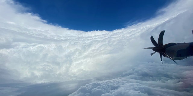
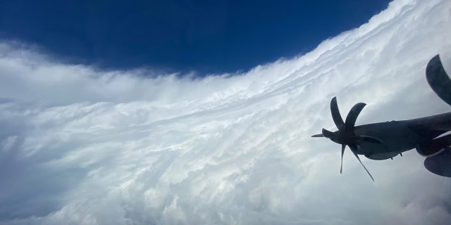
The power of the storm was revealed as a “hurricane hunter” aircraft flew through the storm, which revealed what is known as the “stadium effect” in the eye.

The “stadium effect” of Hurricane Epsilon can be seen on Wednesday, Oct. 21, 2020. (Hurricane Hunters)
The “stadium effect” makes the hurricane eye look like a bowl of a sports stadium.
Photos from the hurricane hunters show the towering eye of the storm with sunlight shining down along the wall of the clouds.

The “stadium effect” of Hurricane Epsilon can be seen on Wednesday, Oct. 21, 2020. (Hurricane Hunters)
The effect is caused by plumes of rapidly-rising air swirling into the storm and moving outwards from the core, causing the eye of the storm to become larger as the altitude above the ocean surface increases, according to the Washington Post.

The “stadium effect” of Hurricane Epsilon can be seen on Wednesday, Oct. 21, 2020. (Hurricane Hunters)
Over the past couple of decades, meteorologists have been increasingly worried about storms that blow up from nothing to a whopper, just like Epsilon. Forecasters created an official threshold for this dangerous rapid intensification — a storm gaining 35 mph in wind speed in just 24 hours.
Video released also shows crews flying through the center of the storm.
“A stunner! Sometimes the views inside these monsters are so magnificent,” tweeted Eric Blake, a senior hurricane scientist at the National Hurricane Center (NHC).
TROPICAL STORM EPSILON FORECAST TO BECOME HURRICANE, PASS NEAR BERMUDA
As of Thursday morning, the storm has weakened slightly to a strong Category 2 storm with maximum sustained winds of 110 mph.

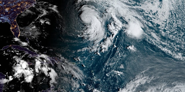
Hurricane Epsilon can be seen over the Atlantic Ocean on Thursday, Oct. 22, 2020. (Fox News)
The storm is located about 260 miles east-southeast of Bermuda, moving northwest at 7 mph. It is forecast to make a turn to the north by late Thursday, accelerating to the northeast through Saturday.
“On the forecast track, the center of Epsilon is forecast to make its closest approach to, but well to the east of, Bermuda later this evening,” the NHC said.
A tropical storm warning is in effect for Bermuda, where tropical storm conditions are expected intermittently through Friday morning as Epsilon passes to the east of the island.

The forecast track of Hurricane Epsilon. (Fox News)
The good news is the storm will stay away from Bermuda, but high waves and rip currents will spread westward toward the East Coast of the U.S.
CLICK HERE FOR MORE WEATHER COVERAGE FROM FOX NEWS
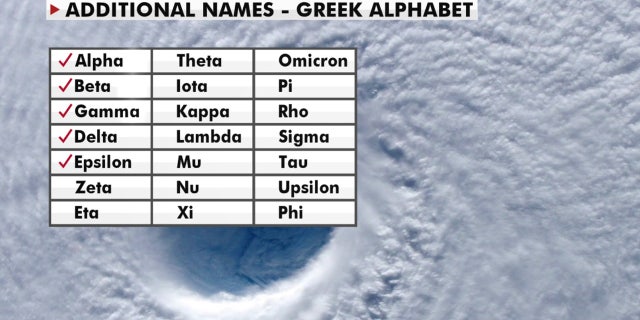
There is just over one month left in the 2020 Atlantic hurricane season, which ends Nov. 30, but this season has broken numerous records as forecasters in September ran out of traditional names and went to the Greek alphabet for storms Alpha and Beta.
NOAA forecasters had called for up to 25 named storms this season with winds of 39 mph or higher; of those, seven to 10 could become hurricanes. Among those hurricanes, three to six will be major, classified as Category 3, 4 and 5 with winds of 111 mph or higher.
That’s far above an average year. Based on 1981-to-2010 data, that is 12 named storms, six hurricanes, and three major hurricanes. So far this year, there have been 26 named storms, including 10 hurricanes, and of those, now four major hurricanes.

A look at the Greek alphabet names that are being used for the 2020 Atlantic hurricane season, after the hurricane center ran out of official names due to the number of storms. (Fox News)
The last time the Greek alphabet was used in the Atlantic was in 2005, the year of Hurricane Katrina. With a total of 27 storms that year, the first six letters of the Greek alphabet were used: Alpha, Beta, Gamma, Delta, Epsilon and Zeta.
CLICK HERE FOR THE FOX NEWS APP
Fox News’ Adam Klotz, Brandon Noriega, and the Associated Press contributed to this report.
>>>details

